The Google Map Image Cutter is an application designed to take any image or digital photo and cut it into tiles which are displayed on a Google Map. Using this tool, large images can be published on the web in a format that allows the user to pan and zoom using the standard Google Maps interface. Although publishing large digital photos is the most obvious application, this technique can also be used for annotated maps of an area that are not to scale e.g. directions for how to get to the office.
![]() Download version 1.4 now (23 May 2008).
Download version 1.4 now (23 May 2008).
Version 1.4 contains a new batch mode feature which allows multiple files to be processed in one operation.
The following images were created using the application. Click on the images to view them using Google Maps.
 | 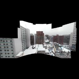 | |
| The Old Dispensary in Newham, Northeast London. | A partial panorama taken from a hotel window in Sapporo, Japan. |
How It Works
The Google Maps Image Cutter takes a large image and cuts it into lots of 256x256 pixel images. At the top level there is only one 256 pixel square which is a smaller copy of the original image. At the next level, there are four 256 pixel squares, then sixteen, sixty four and two hundred and fifty six. This corresponds to 256, 512, 1024, 2048 and 4096 pixel square images spread over the map tiles. The application automatically chooses the depth of the maximum zoom level to correspond to the original size of the image, so zooming in any further would make the image bigger and cause it to pixelate.
Further Information
More detailed information can be found in the readme file installed with the application.
For additional support email support@casa.ucl.ac.uk The Google Map Creator is part of the GeoVUE project at CASA. This project is sponsored by the ESRC as a node in the National Centre for e-Social Science.
site at my work.
Basically the point is to have our plans searchable to be able to find
where other colleagues are located on the floor.
I have designed the floor plan imageries and I even found tile cutters
which leads to me having the floor plan cut in multiple tiles based on
the zoom levels that I specified.
I used the Google Maps Image Cutter at the address:
http://www.casa.ucl.ac.uk/
to make my tiles.
Looking deeper at the Google Maps API tutorials, I would have to host
my floor plans on Google servers, which I am rather hesitant about,
since it would be confidential information.
I also looked at LaudonTech (www.laudontech.com) but I am not too
confortable working with them, since we would want to do it ourselves
with a possible platform like Google Maps that is open source.
Did anyone run into such an issue previously? Is there some sort of
tutorial which I could be referred to where I could follow some
instructions on how to get a basic floor plan with office coordinates
to the different locations where employees are located, and I would
take it from there to continue through that endeavour..

No comments:
Post a Comment